The Slovak Republic is a relatively small, landlocked country in central Europe. Its geography is broadly mountainous in the north, with lower-lying plains in the south. In this blog, we will explore in detail Slovakia geography, including its weather and some more specific places of interest.
Slovakia is bordered by Poland to the north, Ukraine to the east, Hungary to the south, and Austria and the Czech Republic to the west. The topography of Slovakia is dominated by the western Carpathian Mountains and the total area of the country covers 18,859 square miles. Land use is split into 41 percent forests, 31 percent arable land, 17 percent pastures, and three percent cultivated land. The remaining land is divided between arable land, natural hazards, and human infrastructure.
Geography In Slovakia: What Are The Most Amazing Locations In Slovakia?
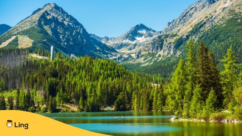
Tatra Mountains
The Tatra Mountains are spread across the central and northern parts of Slovakia and cover around 290 sq miles. They make up the tallest part of the Carpathians and 29 peaks rise above the 2,500-meter mark. The High Tatras is situated in the north of Slovakia along the border with Poland. These mountainous regions of the Carpathian Mountains are popular with skiers during the winter months, and the scenic lakes and mountain valleys attract hikers during the warmer months. Gerlachovský Peak, at 2,655 meters, is the country’s most famous peak and a target for intrepid climbers.
The Western Tatra mountains lie to the west with its highest peak being Bystrá at 2,248 meters. The Belianske Tatras are situated to the east and are the smallest of the Tatras by area. The valley of the Váh river separates the Tatras from the Low Tatras.
To the south are the Slovak Ore Mountains, which are economically important to Slovakia because of an abundance of iron ore and other natural resources.
Rivers
Slovakia’s longest river is the Váh, at 250 miles in length, and the shortest is the Čierna. Rivers, including the Danube River to the south, the Dunajec to the north, and the Morava to the West form natural borders with Slovakia’s neighbors. Many of Slovakia’s rivers have their source high in the Slovak Mountains. Altogether the rivers of Slovakia span some 30,928 miles.
Whereas most rivers will discharge their greatest volume of water during the spring, when meltwater flows out of the mountains, the country’s largest river, the Danube, discharges its highest volume of water during the summer months when the snow melts high up in the Alps. Mountain lakes and thermal and mineral springs are to be found across the country.
Caves
For those interested in outstanding natural geographical features a visit to some of Slovakia’s hundreds of caverns and caves beneath the mountains is a must. Five of Slovakia’s caves have been designated the prestigious UNESCO World Heritage Site status. These are Ochtinská Aragonite Cave, Gombasek Cave, Jasovská Cave, Dobšiná Ice Cave and Domica. Many caves are open to the public, including Demänovská Ice Cave, Bystrianska Cave, Belianska Cave, and Demänovská Cave of Liberty.
Soils
There are a wide variety of soil types spread across Slovakia. Black chernozems occur in the southwest and are extremely fertile. The Slovakian Danube basin provides alluvial deposits known as Great Rye Island. The country’s highest regions are covered in stoney mountain soils, and the lower-lying central and northern part is dominated by podzols. Brown forest soils cover the lands around the southern river valleys’ upper reaches.
Plants And Animals
Slovakia may be a diminutive European country, but it has a surprisingly wide level of biodiversity. The country’s differing topography is home to a diverse animal population. The Tatry National Park in the High Tatras, where hunting has been banned, provides a habitat for martens, minks, marmots, otters, lynx, wildcats, bears, and wolves. The chamois that live here and in other parts of Slovakia are among many of the protected species of Slovakia.
The lowlands and densely forested areas are home to numerous bird species including wild geese, ducks, partridges, and pheasants. Larger birds including hawks, eagles, and storks are protected by law.
Slovakia’s forests have been diminished by farming and logging, although around two-fifths of the country is still covered by forested areas. Most of the trees are to be found in mountainous regions. On the Podunajská Lowlands, oak groves are common. The upper and middle slopes of the Carpathians are home to spruce forests whereas the lower levels give way to forests of beech.
Below the timberline in the Tartras dwarf pines dominate. Above the timberline, at its highest point, the landscape is covered by alpine grasses and small shrubs. Higher up the rocky terrain is dominated by lichens.
Climate
The landlocked country of Slovakia has a continental climate similar to other countries in central Europe with warm summers and cold winters. Weather patterns differ in the mountains and lowlands. Each of Slovakia’s four seasons is approximately equal in length. Oceanic air currents keep the summer temperatures down and bring rain. The damp air causes fog to form in the valleys and eastern Slovak lowlands during the colder months. In contrast, the dry continental air can cause frosts in winter and temperatures to rise in the summer.
Spring officially gets underway on 21 March. The weather can be unpredictable but the days are generally cold with temperatures between nine degrees rising to 17 degrees by the beginning of June.
Slovakia’s summer begins on 22 June when the temperatures increase to around 30 degrees in the day. In southern Slovakia, temperatures can climb as high as 40 degrees in July, the country’s hottest month, although temperatures are usually less intense in the mountainous north. Expect frequent thunderstorms and showers at this time of year.
The Autumn begins on 23 September when the wind picks up and the rains arrive. Although the temperatures will drop in September, October can be dry and sunny.
Winter starts on 21 December, just before Christmas, when temperatures drop to sub-zero. It is usual to have snowfall during December and January and temperatures are predictably lower in the mountains.
Slovak Geography Terms To Enhance Your Vocabulary
Now that we’ve learned a bit about Slovakia’s geography, we should learn a few terms related to this topic in Slovak. In the following table, you have a collection of terms along with the translation to Slovak. To practice your pronunciation, press the little blue button and listen to how the word is said in Slovak.

Download The Ling App And Improve Your Vocabulary In Slovakian
If you are planning a visit to Slovakia, why not download the Ling app to your mobile device? Having a language app to hand will ensure that exploring Slovakia is made fun and easy. Improving your Slovakian will ensure that booking hotels and excursions as well as eating out and making new friends is made simple.
Ling has more than 60 languages in its repertoire and lessons are made more interesting through interactive quizzes and games. Download Ling at App Store and Google Play today.